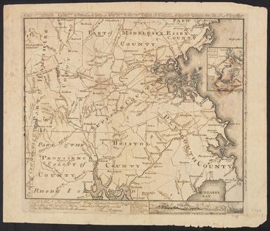
Detail View: Yale University Maps: [Map of Eastern Massachusetts, including parts of Plymouth, Bristol, Suffolk, Hampshire, Middlesex and Essex Counties, with a portion of Providence County of Rhode Island included] Inscription reads: To the Hone. Jno. Hancook Esqre. President of ye Contin
|
Published/Created Date:
|
[1775?]
|
|
Extent:
|
1 map ; 36 x 43 cm.
|
|
Extent of Digitization:
|
Complete work digitized.
|
|
Call Number:
|
764 1775
|
|
Format:
|
cartographic
|
|
Access:
|
Public
|
|
Rights:
|
The use of this image may be subject to the copyright law of the United States (Title 17, United States Code) or to site license or other rights management terms and conditions. The person using the image is liable for any infringement
|
|
Orbis ID:
|
8254142
|
|
OID:
|
15639969
|
|
Image OID:
|
15653920
|
|
Title:
|
[Map of Eastern Massachusetts, including parts of Plymouth, Bristol, Suffolk, Hampshire, Middlesex and Essex Counties, with a portion of Providence County of Rhode Island included] Inscription reads: To the Hone. Jno. Hancook Esqre. President of ye Contin
|
|
Attribution:
|
Yale University Library
|
|
Language:
|
English
|
|
Genre:
|
Maps
|
|
Resource Type:
|
Maps, Atlases & Globes
|
|
Container / Volume Information:
|
BRBL_00452
|
|
Description:
|
Insets: Plan of Boston and its Environs, 1775. ca. 1:135,000 9 x 7 cm.
|
|
Scale:
|
Scale [ca. 1:280,000].
|
|
Image Label:
|
recto
|