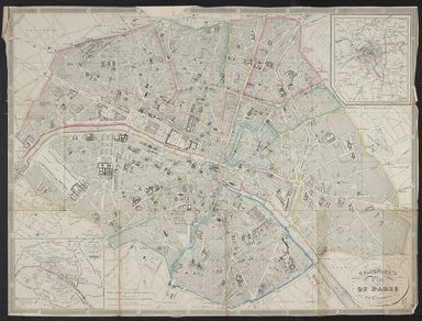
Detail View: Yale University Maps: Galignani's plan of Paris and environs / drawn by Achin ; engraved by Hacq.
|
Published/Created Date:
|
184-?]
|
|
Publication Place:
|
[Paris? :
|
|
Publisher:
|
Calignani,
|
|
Extent:
|
1 map : hand colored ; 39 x 55 cm, folded in cover 16 x 10 cm + index (xii pages ; 17 cm)
|
|
Extent of Digitization:
|
Complete work digitized.
|
|
Call Number:
|
38 P21 1867B
|
|
Format:
|
cartographic
|
|
Access:
|
Public
|
|
Rights:
|
The use of this image may be subject to the copyright law of the United States (Title 17, United States Code) or to site license or other rights management terms and conditions. The person using the image is liable for any infringement
|
|
Orbis ID:
|
8280844
|
|
OID:
|
15497618
|
|
Image OID:
|
15497629
|
|
Title:
|
Galignani's plan of Paris and environs / drawn by Achin ; engraved by Hacq.
|
|
Attribution:
|
Yale University Library
|
|
Creator:
|
A. and W. Galignani (Firm)
|
|
Language:
|
English
|
|
Genre:
|
Maps
|
|
Resource Type:
|
Maps, Atlases & Globes
|
|
Container / Volume Information:
|
BRBL_00163
|
|
Description:
|
Coordinates not present on map and are approximated.
|
|
Subject (Geographic):
|
Paris (France)--Maps
|
|
Subject (Name):
|
Achin
|
|
Copyright Date:
|
[1851?]
|
|
Scale:
|
Scale approximately 1:15,600
|
|
Coordinates:
|
(E 2°17ʹ00ʺ--E 2°24ʹ26ʺ/N 48°53ʹ18ʺ--N 48°49ʹ39ʺ).
|
|
Image Label:
|
recto
|